LANSING, Mich. — Ice totals could approach the amounts observed in 2013. The impacts this time might actually be more widespread than that benchmark. Let's dive into the expectations vs. what we know happened back then.
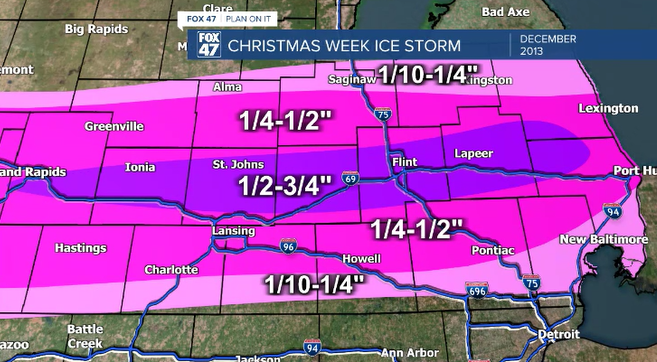
2013 brought an ice storm to the FOX47 viewing area that caused damage and lengthy power outages. Some of those outages lasted longer than a week because of tree and power line damage. Ice totals along the I-69 corridor hit 3/4" in some locations. As you can see on the map below, the area of highest ice totals was relatively thin and crossed the entire state.

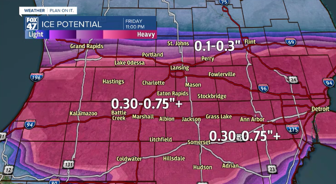
Jackson picked up next to nothing while I-96 and I-69, and the 10 miles on either side of them, took the brunt of the ice. This time, we could be looking at a much larger area with ice totals between 1/2-3/4". This would mean we could potentially expect more outages and more widespread damage than 2013. As seen on our map below, the area that could be impacted might be 3-4x larger in scale.

As you can see, that is a much larger area for potential damaging ice totals than 2013. This time we could expect high winds as well.
Wednesday, a northeast wind could gust over 35mph as ice is accumulation on power lines and tree branches. Hopefully we melt some of that off on Thursday, because if we don't, winds gusting to 50mph could cause even more damage.
While no two storm are exactly the same, the crippling ice storm in 2013 does have the chance to be surpassed by this one. Of course, things could change, and hopefully they will. No one wants a repeat of Christmas week 2013 nearly 10 years later.
Want to see more local news? Visit the FOX47News Website.
For more news in your neighborhood, go to our In Your Neighborhood page on our website.
Stay in touch with us anytime, anywhere.
Sign up for newsletters emailed to your inbox.
Select from these options: Neighborhood News, Breaking News, Severe Weather, School Closings, Daily Headlines, and Daily Forecasts.


